In 1989, President George H.W. Bush signed into law the Global Change Research Act (GCRA), formally mandating the U.S. Global Change Research Program (USGCRP). The program was first proposed during President Ronald Reagan’s final budget and was unanimously passed by the Senate, 100-0. The GCRA mandates that the USGCPR regularly produce a comprehensive assessment of climate science and the potential effects of climate change on the nation. On Friday, November 23, 2018, while many of us were making turkey sandwiches, watching football, and engaging in some Black Friday shopping, the U.S. government released the USGCRP’s Fourth National Climate Assessment, a detailed report “written to help inform decision-makers, utility and natural resource managers, public health officials, emergency planners, and other stakeholders by providing a thorough examination of the effects of climate change on the United States.”
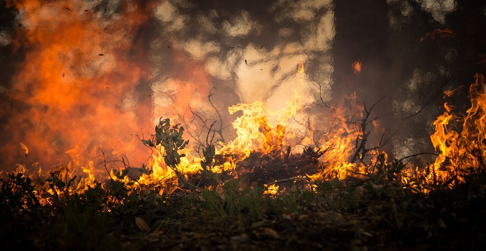
As the owner of rural property, you are the decision-maker, natural resource manager, emergency planner, and stakeholder. The information in this report applies to you. For those interested in not-so-light reading, the entire report is available online at https://www.globalchange.gov/nca4. The report itself is massive, but you can easily view individual chapters which are broken down by subjects and regions of the U.S., including Southwest. While the Fourth National Climate Assessment covers a variety of subjects, in the wake of the recent California wildfires and the devastating 2011 Texas wildfires still in the rearview mirror, a key takeaway for landowners in the report is being prepared for “increasing wildfire frequency.”
For those of you who might not trust a big report from big government, bear in mind these words from Bob Watson, fire chief in the Panhandle city of Borger, as reported in Texas A&M Forest Service’s 2011 Texas Wildfires Common Denominators of Home Destruction:
“Fire is not going away,” Watson said. “Fire behavior is changing. Climate is changing. There are a lot of things that point to our fires getting worse instead of better.”
In addition to climate change, wildfires are becoming a greater risk due to the increase in the Wildland-Urban Interface. As explained by the Ready, Set, Go! Program, a program managed by the International Association of Fire Chiefs and created to develop and improve dialogue between fire departments and the residents they serve:
“Citizens are moving farther into ‘natural’ areas to take advantage of the privacy, natural beauty, recreational opportunities and affordable living. Developers are building neighborhoods to accommodate the influx. As a result, fire departments are fighting fires along the Wildland-Urban Interface (WUI), defined as areas where homes are built near or among lands prone to wildland fire…The increase in the WUI threat has been steep because of continued development and exposure.
“The WUI is not a place, per se, but a set of conditions that can exist in nearly every community. It can be a major subdivision or it can be four homes on an open range. According to the National Fire Protection Association, conditions include (but are not limited to): the amount, type, and distribution of vegetation; the flammability of the structures (homes, businesses, outbuildings, decks, fences) in the area, and their proximity to fire-prone vegetation and to other combustible structures; weather patterns and general climate conditions; topography; hydrology; average lot size; and road construction. The WUI exists in every state in the country.”
So, how can you protect your property?
The details of the various measures you can take to protect the structures and animals on your property are beyond the scope of this article. The following, rather, provides a brief overview along with resources for your edification, but, most of all, it should encourage you to do your own research and planning. You know the specifics of your property. You are the decision-maker, natural resource manager, emergency planner, and stakeholder. As noted in Protecting Your Home from Wildfire: Creating Wildfire-Defensible Zones, a publication of the Colorado Forest Service:
“Firefighters will do their best to protect homes, but ultimately it is the homeowner’s responsibility to plan ahead and take actions to reduce fire hazards around structures.”
Wildfire-Defensible Zones
As you will find in a variety of widely available wildfire education resources, there are a number of ways to protect structures from burning, many of them depending on the construction of the structure. For example, wildfires driven by high winds can send a profuse amount of embers ahead of the main fire. Those winds can force embers into home ventilation systems and underneath pier and beam foundations, igniting homes from within. Because vents provide the perfect opening for embers, adding a 1/8-inch metal screen over vent openings can create a barrier. The type of foundation, windows, roof, siding, decking, and more can all impact the wildfire risk of structures on your property. But one method of wildfire protection that most, if not all, rural property owners can create to some degree is wildfire-defensible zones.
The Colorado Forest Services lays out a three-zone strategy for this method. A link to this information found in Protecting Your Home from Wildfire: Creating Wildfire-Defensible Zones is in the resource list, below. While it is clearly written for the heavily forested areas of Colorado, the three-zone strategy offers a common-sense way to consider wildfire protection for your Texas property:
Zone 1 – the area nearest the home and other structures. This zone requires maximum hazard reduction. Typically extends a minimum distance of 15-30 feet outward from a structure, depending on property size. Most flammable vegetation is removed in this zone, for example, with the possible exception of a few low-growing shrubs or fire-resistant plants.
Zone 2 – a transitional area of fuels (flammables such as dead and diseased trees, for example) reduction between Zones 1 and 3. Typically, the defensible space in Zone 2 should extend at least 100 feet from all structures.
Zone 3 – the area farthest from the home. It extends from the edge of Zone 2 to your property boundaries. As noted in the information, mowing grasses is not necessary in Zone 3.
Finally, above, all, use common sense. In Protecting Your Wildland Home from Wildfire, author Tilda Mims, Education Specialist with the Alabama Forestry Commission, presents a wealth of logical tips including:
- Remove things that burn easily from at least 30 feet around the house.
- Evergreen trees burn easily. Prune their lower limbs, and thin the trees or remove them from around your home.
- Clean gutters and roof of leaves and limbs.
- Remove tree limbs that hang over your roof and power lines.
- Remove combustible materials and debris that accumulate under decks and terraces.
As Mims concludes: “Though you can never fully protect your home and adjacent woodlands against wildfires, you can take steps to reduce the risk. After all, it is a small price to pay for the many benefits of rural life.”
Resources
2011 Texas Wildfires Common Denominators of Home Destruction (Texas A&M Forest Service)
Protecting Your Home from Wildfire: Creating Wildfire-Defensible Zones (Colorado Forest Service)
Readyforwildfire.org (California Department of Forestry & Fire Protection)
Ready, Set, Go! (RSG) Program (International Association of Fire Chiefs)
Protecting Your Wildland Home from Wildfire (Alabama Forestry Commission)